
Data is organized by theme, subfolder, data layer, specific file of larger data set where applicable. .
All data layers listed below are available for download at Vermont Center for Geographic Information (VCGI).
Theme: Agriculture and Farming
Subfolder: Land
Data Layer: GeologicSoils_SO: soils- Natural Resource Conservation Service soil survey.
File: GeologicSoils_SO07.zip: Soils of Chittenden County, Vermont.
Theme: Basemaps (Scanned Map and Charts)
Subfolder: Scanned Maps
Data Layer: BasemapScanmaps_Topo24K: USGS Topographic Maps (1:24,000- New US Topo Maps)File:
File: US_Topo_Colchester_Point.zip: USGS Topographic Map of Colchester Point
Theme: Biological and Ecological
Subfolder: Habitat
Data Layer EcologicHabitat_HABITATBLKS: Vermont habitat blocks and wildlife corridors. (Areas of natural habitat that are unfragmented by roads, development, or agriculture.)
Data Layer EcologicHabitat_HOTSPOTS: Biological hotspots in Vermont. (Areas of high biological significance or diversity.)
Subfolder: Other
Data Layer: EcologicOther_RTENATCOM: (Rare, threatened and endangered species and significant communities in Vermont.)
Data Layer: EcologicOther_UNCOMSPOF: (Uncommon species and other features in Vermont.)
Theme: Fresh Water Resources
Subfolder: Wetlands
Data Layer: WaterWetlands_VSWI: Vermont Significant Wetlands Inventory (VSWI).
Theme: Geologic and Geophysical Limitations
Subfolder: Bedrock
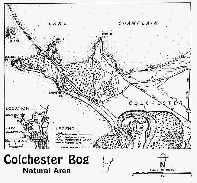
Data Layer: GeologicBedrock_BEDROCK9: Bedrock classification in Vermont.There are three classes (I= Carbonate Rich bedrock, II= Metamorphic Bedrock, III= Other) and 9 subclasses. Colchester Bog is Class I, Subclass 2: calcerous clastic and metamorphic clastic rocks containing approximately 15-45% carbonate material, including calcerous slates.
Subfolder: Landforms
Data Layer: GeologicSurficial_LANDFORMS: Landforms in Vermont.
Colchester Bog is classified as a wetland, and can be found as FID 55
Data Layer: GeologicSurficial_SURFICIAL62K: Surficial geology data- 1:62,500.
Colchester Bog can be found as FID 3522. Feature type= pluvial deposit, name/description= swamp, peat and/or muck.